|
Aircraft
and Human Performance |
Aircraft Systems
|
| Basic
Aerodynamics |
Communication Procedures |
Enroute Flight |
|
Flight Instruments
|
Navigation |
Procedures and Airport Operations |
| Regulations | Weather | Weather Services | First Aid & Physiology |
Weather
Table of Contents
The Heating of the EarthCirculation and Wind
Temperature
Moisture
Air Masses and Fronts
Stability of the Atmosphere
Clouds
Turbulence
Thunderstorms
Wind Shear
Icing
Fog
Frost
Structure of the Atmosphere
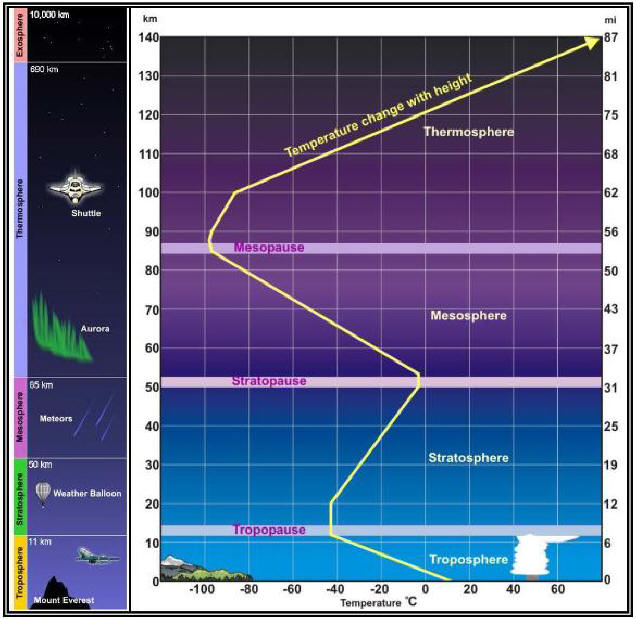
The Heating of the Earth
The major source of all weather is the sun. Changes or variations of weather patterns are caused by the unequal heating of the Earth’s surface.
Every physical process of weather is accompanied by or is a result of unequal heating of the Earth’s surface. The heating of the Earth (and therefore the heating of the air surrounding the Earth) is unequal around the entire planet. Both north or south of the equator, one square foot of sunrays is not concentrated over one square foot of the surface, but over a larger area. This lower concentration of sunrays produces less radiation of heat over a given surface area; therefore, less atmospheric heating takes place in that area.
The unequal heating of the Earth’s atmosphere creates a large air cell circulation pattern (wind) because the warmer air has a tendency to rise (low pressure) and the colder air has a tendency to settle or descend (high pressure) and replace the rising warmer air. This unequal heating, which causes pressure variations, will also cause variations in altimeter settings between weather reporting points.
Because the Earth rotates, this large, simple air cell circulation pattern is greatly distorted by a phenomenon known as the Coriolis force. When the wind (which is created by high pressure trying to flow into low pressure) first begins to move at higher altitudes, the Coriolis force deflects it to the right (in the Northern Hemisphere) causing it to flow parallel to the isobars (lines of equal pressure). These deflections of the large-cell circulation pattern create general wind patterns as depicted below
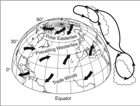
Circulation and Wind
The general circulation and wind rules in the Northern Hemisphere are as follows:
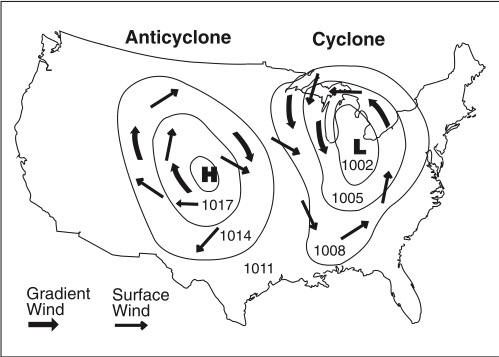
1. Air circulates in a clockwise direction around a high;
2. Air circulates in a counterclockwise direction around a low;
3. The closer the isobars are together, the stronger the wind speed; and
4. Due to surface friction (up to about 2,000 feet AGL), surface winds do not exactly parallel the isobars, but move outward from the center of the high toward lower pressure. See Figure 6-2.
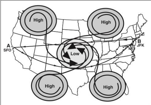
Knowing that air flows out of the high in a clockwise direction and into the low in a counterclockwise direction is useful in preflight planning. Assume a flight from point A to point B as shown in Figure 6-3. Going direct would involve fighting the wind flowing around the low. However, by traveling south of the low-pressure area, the circulation pattern could help instead of hinder. Generally speaking, in the Northern Hemisphere, when traveling west to east, the most favorable winds can be found by flying north of high-pressure areas and south of low-pressure areas. Conversely, when flying east to west, the most favorable winds can be found south of high-pressure areas and north of low-pressure areas.
Temperature
In aviation, temperature is measured in degrees Celsius (°C). The standard temperature at sea level is 59°F (15°C). The average decrease in temperature with altitude (standard lapse rate) is 2°C (3.5°F) per 1,000 feet. Since this is an average, the exact value seldom exists; in fact, temperature sometimes increases with altitude (an inversion). The most frequent type of ground- or surface-based temperature inversion is one that is produced by terrestrial radiation on a clear, relatively still night.
Moisture
Air has moisture (water vapor) in it. The water vapor content of air can be expressed in two different ways. The two commonly used terms are relative humidity and dew point.
Relative humidity relates the actual water vapor present in the air to that which could be present in the air. Temperature largely determines the maximum amount of water vapor that air can hold. Warm air can hold more water vapor than can cold air. See Figure 6-4.
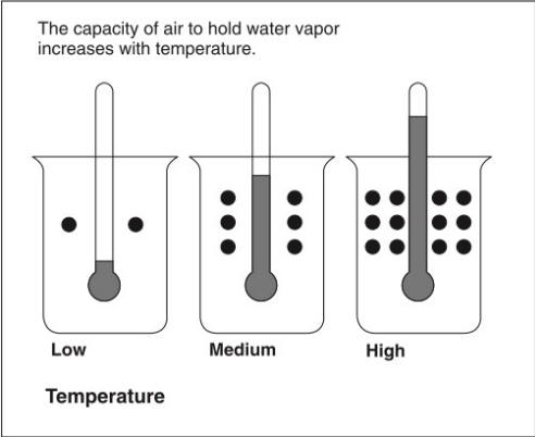
Air with 100 percent relative humidity is said to be saturated, and less than 100 percent is unsaturated.
Dew point is the temperature to which air must be cooled to become saturated by the water already present in the air. See Figure 6-5.
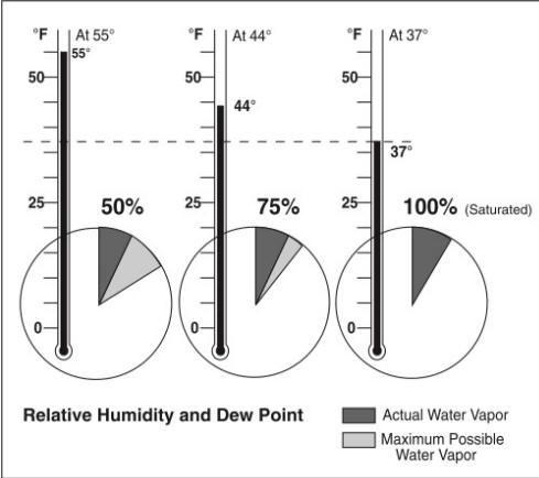
Moisture can be added to the air by either evaporation or sublimation. Moisture is removed from the air by either condensation or sublimation.
When water vapor condenses on large objects such as leaves, windshields, or airplanes, it will form dew; and when it condenses on microscopic particles such as salt, dust, or combustion by-products (condensation nuclei), it will form clouds or fog.
To summarize, relative humidity can be increased either by lowering the air temperature or by increasing the amount of moisture in the air. If the temperature and dew point spread is small and decreasing, condensation is about to occur. If the temperature is above freezing, the weather most likely to develop will be fog or low clouds.
Air Masses and Fronts
When a body of air comes to rest on, or moves slowly over, an extensive area having fairly uniform properties of temperature and moisture, the air takes on these properties. The area over which the air mass acquires its identifying distribution of temperature and moisture is its source region. As this air mass moves from its source region, it tends to take on the properties of the new underlying surface. The trend toward change is called air mass modification.
A ridge is an elongated area of high pressure. A trough is an elongated area of low pressure. All fronts lie in troughs. A cold front is the leading edge of an advancing cold air mass. A warm front is the leading edge of an advancing warm air mass. Warm fronts move about half as fast as cold fronts. Frontal waves and cyclones (areas of low pressure) usually form on slow-moving cold fronts or stationary fronts. Figure 6-6 shows the symbols that would appear on a weather map.
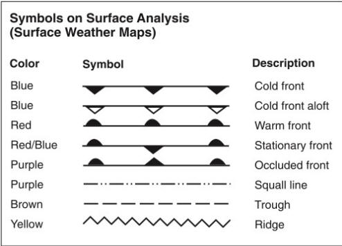
The physical manifestations of a warm or cold front can be different with each front. They vary with the speed of the air mass on the move and the degree of stability of the air mass being overtaken. A stable air mass forced aloft will continue to exhibit stable characteristics, while an unstable air mass forced to ascend will continue to be characterized by cumulus clouds, turbulence, showery precipitation, and good visibility.
Frontal passage will be indicated by the following discontinuities:
1. A temperature change (the most easily recognizable discontinuity);
2. A continuous decrease in pressure followed by an increase as the front passes; and
3. A shift in the wind direction, speed, or both.
Stability of the Atmosphere
Atmospheric stability is defined as the resistance of the atmosphere to vertical motion. A stable atmosphere resists any upward or downward movement. An unstable atmosphere allows an upward or downward disturbance to grow into a vertical (convective) current.
Determining the stability of the atmosphere requires measuring the difference between the actual existing (ambient) temperature lapse rate of a given parcel of air and the dry adiabatic (3°C per 1,000 feet) lapse rate.
A stable layer of air would be associated with a temperature inversion. Warming from below, on the other hand, would decrease the stability of an air mass.
The conditions shown in Figure 6-7 can be characteristic of stable or unstable air masses.
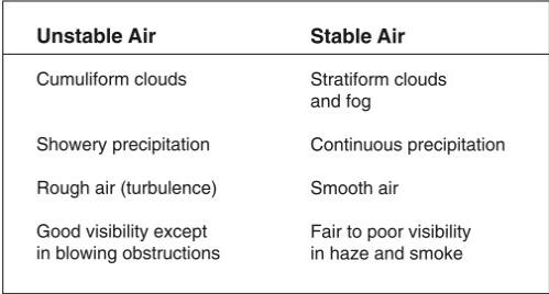
Clouds
Stability determines which of two types of clouds will be formed: cumuliform or stratiform.
Cumuliform clouds are the billowy-type clouds having considerable vertical development, which enhances the growth rate of precipitation. They are formed in unstable conditions, and they produce showery precipitation made up of large water droplets. See Figure 6-8.
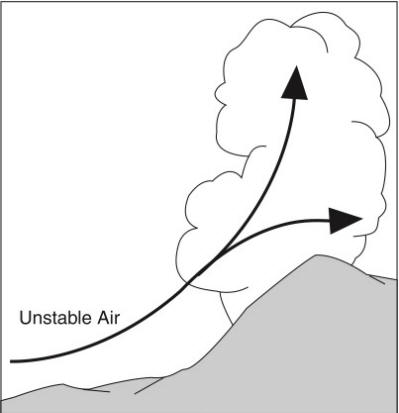
Stratiform clouds are the flat, more evenly based clouds formed in stable conditions. They produce steady, continuous light rain and drizzle made up of much smaller raindrops. See Figure 6-9.
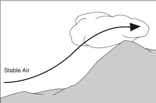
Steady precipitation (in contrast to showery) preceding a front is an indication of stratiform clouds with little or no turbulence.
Clouds are divided into four families according to their height range: low, middle, high, and clouds with extensive vertical development. See Figure 6-10.
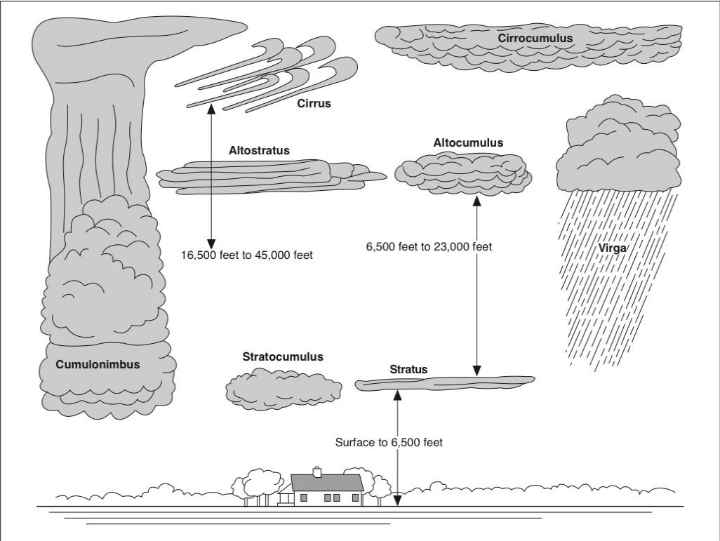
The first three families—low, middle, and high—are further classified according to the way they are formed. Clouds formed by vertical currents (unstable) are cumulus (heap) and are billowy in appearance. Clouds formed by the cooling of a stable layer are stratus (layered) and are flat and sheet-like in appearance. A further classification is the prefix “nimbo-” or suffix “-nimbus,” which means raincloud.
High clouds, called cirrus, are composed mainly of ice crystals; therefore, they are least likely to contribute to structural icing (since it requires water droplets).
The base of a cloud (AGL) that is formed by vertical currents (cumuliform clouds) can be roughly calculated by dividing the difference between the surface temperature and dew point by 4.4 and multiplying the rounded result by 1,000. The convergence of the temperature and the dew point lapse rate is 4.4°F per 1,000 feet.
Problem: What is the approximate base of the cumulus clouds if the surface air temperature is 70°F and the dew point is 61°F?
Solution:
Use the following steps:
1.

2. 9 ÷ 4.4 = 2.05 or 2
3. 2 × 1,000 = 2,000 feet AGL (base of cloud)
Turbulence
Cumulus clouds are formed by convective currents (heating from below); therefore, a pilot can expect turbulence below or inside cumulus clouds, especially towering cumulus clouds. The greatest turbulence could be expected inside cumulonimbus clouds.
If severe turbulence is encountered either inside or outside of clouds, the airplane’s airspeed should be reduced to maneuvering speed and the pilot should attempt to maintain a level flight attitude because the amount of excess load that can be imposed on the wing will be decreased. Any attempt to maintain a constant altitude will greatly increase the stresses that are applied to the aircraft.
Thunderstorms
Thunderstorms present many hazards to flying. Three conditions necessary to the formation of a thunderstorm are:
1. Sufficient water vapor;
2. An unstable lapse rate; and
3. An initial upward boost (lifting).
The initial upward boost can be caused by heating from below, frontal lifting, or by mechanical lifting (wind blowing air upslope on a mountain).
There are three stages of a thunderstorm: the cumulus, mature, and dissipating stages. See Figure 6-11.
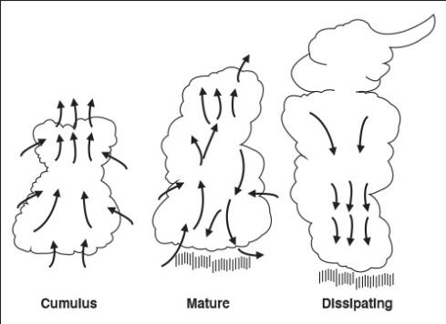
The cumulus stage is characterized by continuous updrafts, and these updrafts create low-pressure areas. Thunderstorms reach their greatest intensity during the mature stage, which is characterized by updrafts and downdrafts inside the cloud. Precipitation inside the cloud aids in the development of these downdrafts, and the start of rain from the base of the cloud signals the beginning of the mature stage. The precipitation that evaporates before it reaches the ground is called virga. The dissipating stage of a thunderstorm is characterized predominantly by downdrafts.
Lightning is always associated with a thunderstorm.
Hail is formed inside thunderstorms by the constant freezing, melting, and refreezing of water as it is carried about by up- and downdrafts.
A pilot should always expect the hazardous and invisible atmospheric phenomena called wind shear turbulence when operating anywhere near a thunderstorm (within 20 NM).
Thunderstorms that generally produce the most intense hazard to aircraft are called squall line thunderstorms. These non-frontal, narrow bands of thunderstorms often develop ahead of a cold front.
Embedded thunderstorms are those that are obscured by massive cloud layers and cannot be seen.
Wind Shear
Wind shear is defined as a change in wind direction and/or speed over a very short distance in the atmosphere. This can occur at any level of the atmosphere and can be detected by the pilot as a sudden change in airspeed.
Low-level (low-altitude) wind shear can be expected during strong temperature inversions, on all sides of a thunderstorm and directly below the cell. A pilot can expect a wind shear zone in a temperature inversion whenever the wind speed at 2,000 feet to 4,000 feet above the surface is at least 25 knots.
Low-level wind shear can also be found near frontal activity because winds can be significantly different in the two air masses which meet to form the front.
In warm front conditions, the most critical period is before the front passes. Warm front shear may exist below 5,000 feet for about 6 hours before surface passage of the front. The wind shear associated with a warm front is usually more extreme than that found in cold fronts.
The shear associated with cold fronts is usually found behind the front. If the front is moving at 30 knots or more, the shear zone will be 5,000 feet above the surface 3 hours after frontal passage.
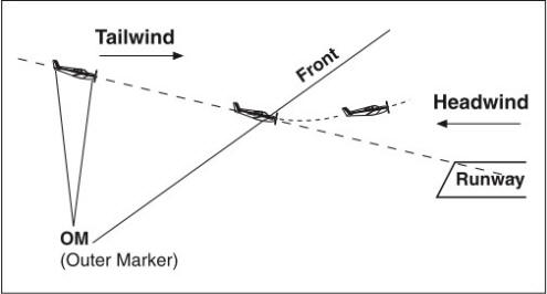
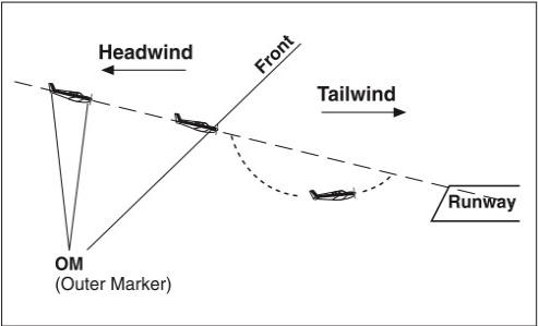
Basically, there are two potentially hazardous shear situations—the loss of a tailwind or the loss of a headwind.
A tailwind may shear to either a calm or headwind component. The airspeed initially increases, the aircraft pitches up, and altitude increases. Lower than normal power would be required initially, followed by a further decrease as the shear is encountered, and then an increase as the glide slope is regained. See Figure 6-12.
A headwind may shear to a calm or tailwind component. Initially, the airspeed decreases, the aircraft pitches down, and altitude decreases. See Figure 6-13.
Some airports can report boundary winds as well as the wind at the tower. When a tower reports a boundary wind which is significantly different from the airport wind, there is a possibility of hazardous wind shear.
Icing
Structural icing occurs on an aircraft whenever supercooled condensed droplets of water make contact with any part of the aircraft that is also at a temperature below freezing. An inflight condition necessary for structural icing to form is visible moisture (clouds or raindrops).
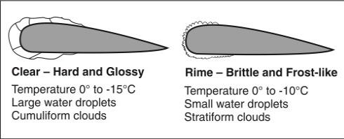
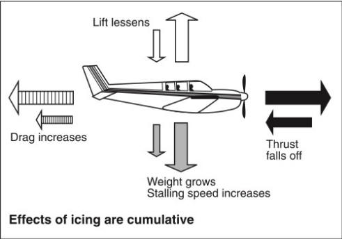
Icing in precipitation (rain) is of concern to the VFR pilot because it can occur outside of clouds. Aircraft structural ice will most likely have the highest accumulation in freezing rain which indicates warmer temperature at a higher altitude. See Figure 6-14. The effects of structural icing on an aircraft may be seen in Figure 6-15.
The presence of ice pellets at the surface is evidence that there is freezing rain at a higher altitude, while wet snow indicates that the temperature at your altitude is above freezing. A situation conducive to any icing would be flying in the vicinity of a front.
Fog
Fog is a surface-based cloud (restricting visibility) composed of either water droplets or ice crystals. Fog may form by cooling the air to its dew point or by adding moisture to the air near the ground. A small temperature/dew point spread is essential to the formation of fog. An abundance of condensation nuclei from combustion products makes fog prevalent in industrial areas.
Fog is classified by the way it is formed.
Radiation fog (ground fog) is formed when terrestrial radiation cools the ground, which in turn cools the air in contact with it. When the air is cooled to its dew point (or within a few degrees), fog will form. This fog will form most readily in warm, moist air over low, flatland areas on clear, calm (no wind) nights.
Advection fog (sea fog) is formed when warm, moist air moves (wind is required) over colder ground or water (e.g., an air mass moving inland from the coast in winter).
Upslope fog is formed when moist, stable air is cooled to its dew point as it moves (wind is required) up sloping terrain. Cooling will be at the dry adiabatic lapse rate of approximately 3°C per 1,000 feet.
Precipitation (rain or drizzle) induced fog is most commonly associated with frontal activity and is formed by relatively warm drizzle or rain falling through cooler air. Evaporation from the precipitation saturates the cool air and fog forms. This fog is especially critical because it occurs in the proximity of precipitation and other possible hazards such as icing, turbulence, and thunderstorms.
Steam fog forms in the winter when cold, dry air passes from land areas over comparatively warm ocean waters. Low-level turbulence can occur and icing can become hazardous in a steam fog.
Frost
Frost is described as ice deposits formed by sublimation on a surface when the temperature of the collecting surface is at or below the dew point of the adjacent air and the dew point is below freezing.
Frost causes early airflow separation on an airfoil resulting in a loss of lift. Therefore, all frost should be removed from the lifting surfaces of an airplane before flight or it may prevent the airplane from becoming airborne.