|
Aircraft
and Human Performance |
Aircraft Systems
|
| Basic
Aerodynamics |
Communication Procedures |
Enroute Flight |
|
Flight Instruments
|
Navigation |
Procedures and Airport Operations |
| Regulations | Weather | Weather Services | First Aid & Physiology |
Weather Services
Table of Contents
Aviation Routine Weather Report (METAR)Pilot Weather Reports (PIREPs) (UA)
Terminal Aerodrome Forecast (TAF)
Graphical Forecasts for Aviation (GFA)
Winds and Temperatures Aloft Forecast (FB)
Inflight Weather Advisories (WA, WS, WST)
Obtaining a Telephone Weather Briefing
Sigments
Aviation Routine Weather Report (METAR)
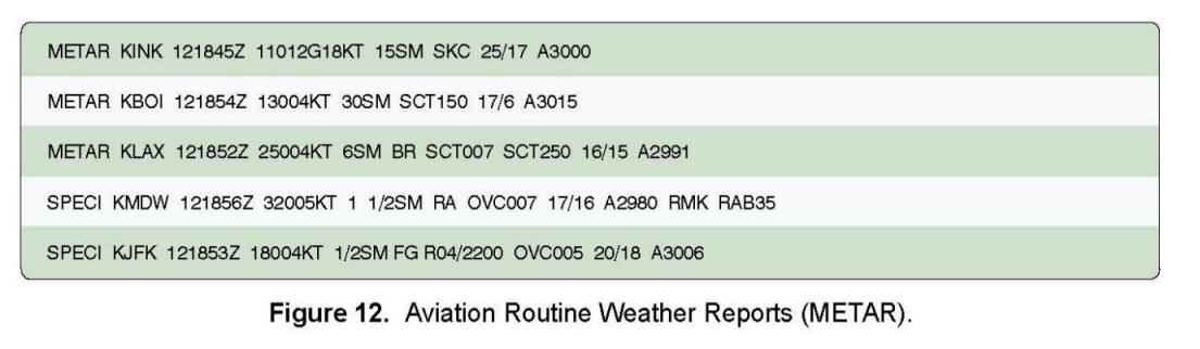
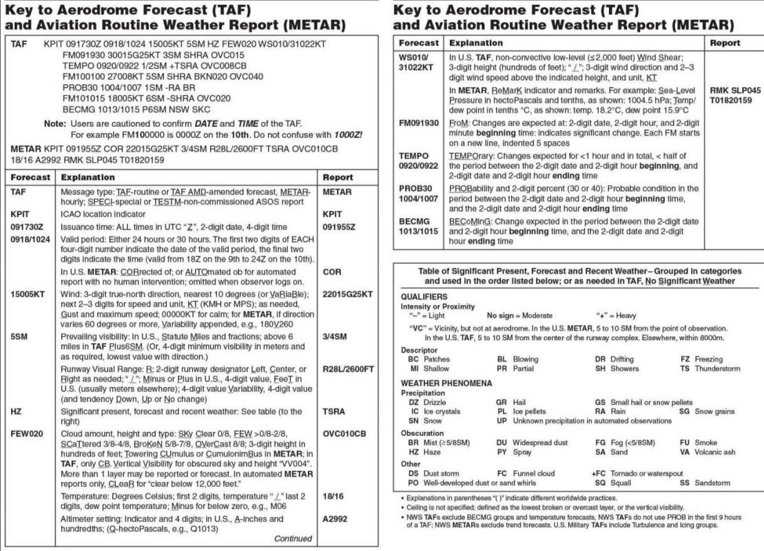
An international weather reporting code is used for weather reports (METAR) and forecasts (TAFs) worldwide. The reports follow the format shown in Figure 7-1.
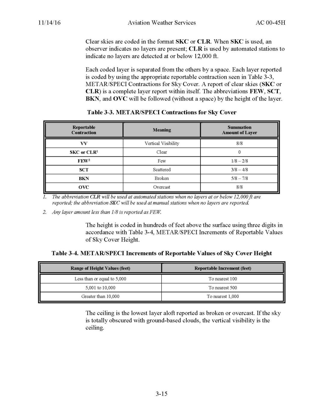
For aviation purposes, the ceiling is the lowest broken or overcast layer, or vertical visibility into an obscuration.
Pilot Weather Reports (PIREPs) (UA)
Aircraft in flight are the only means of directly observing cloud tops, icing, and turbulence; therefore, no observation is more timely than one made from the cockpit. While the FAA encourages pilots to report inflight weather, a report of any unforecast weather is required by regulation. A PIREP (identified by the letters “UA”) is usually transmitted in a prescribed format. See Figure 7-2.
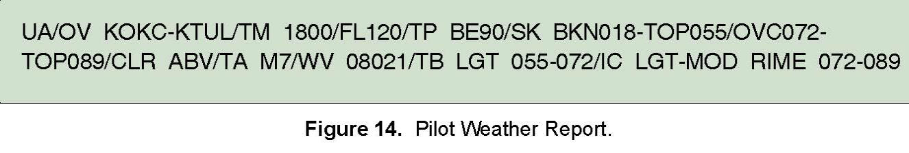
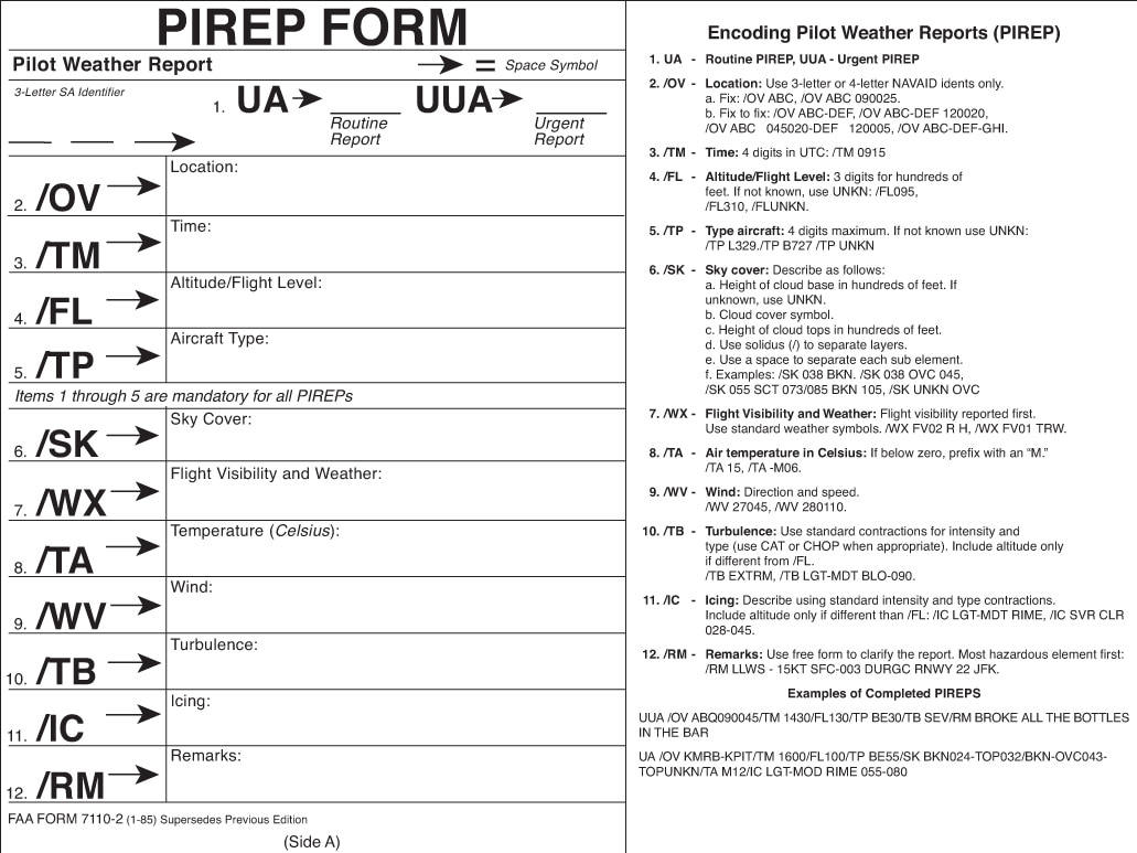
UA/OV KOKC-KTUL/TM 1800/FL120/TP BE90//SK BKN018-TOP055/OVC072-TOP089/CLR ABV/TA M7/WV 08021/TB LGT 055-072/IC LGT-MOD RIME 072-089.
Decodes as follows:
Pilot report, Oklahoma City to Tulsa at 1800Z at 12,000 feet.
Type of aircraft is a Beech King Air 90.
The first cloud layer has a base of 1,800 feet broken, with tops at 5,500 feet.
The second cloud layer base is 7,200 feet overcast with tops at 8,900 feet.
It is clear above.
Outside air temperature is -7° Celsius.
The wind is 080° at 21 knots.
There is light turbulence between 5,500 feet and 7,200 feet.
There is light to moderate rime icing reported between 7,200 feet and 8,900 feet.
Terminal Aerodrome Forecast (TAF)
A Terminal Aerodrome Forecast (TAF) is a concise statement of the expected meteorological conditions at an airport during a specified period (usually 24 hours). TAFs use the same code used in the METAR weather reports:
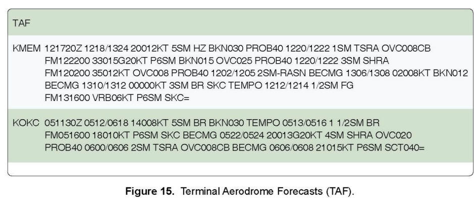
TAFs are issued in the following format:
TYPE / LOCATION / ISSUANCE TIME / VALID TIME / FORECAST
Note: The “/” above are for separation purposes and do not appear in the actual TAFs.
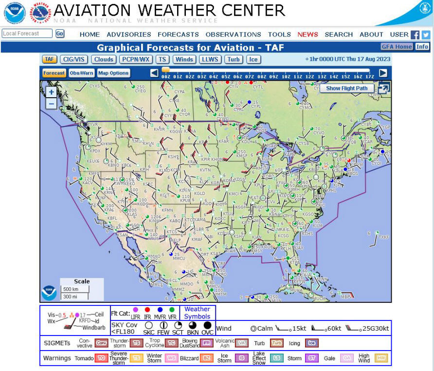
https://aviationweather.gov/gfa
The GFA at the Aviation Weather Center (AWC) website is an interactive display providing continuously updated observed and forecast weather information over the continental United States (CONUS). It is intended to give users a complete picture of weather critical to aviation safety. The GFA display shows user-selected weather categories, each containing multiple fields of interest at altitudes from the surface up to FL480. Depending on the field of interest chosen, weather information is available from -14 hours in the past (observed) to +18 hours in the future (forecast).
The GFA is not considered a weather product but an aggregate of several existing weather products. The information and data from the various weather products are overlaid on a high-resolution basemap of the United States: . The user selects flight levels and current time period for either observed or forecast weather information. Mouse-clicking or hovering over the map provides additional information in textual format, such as current METAR or TAF for a selected airport. The GFA replaces the textual area forecast (FA) for the CONUS and Hawaii with a more modern digital solution for obtaining weather information. The Aviation Surface Forecast and Aviation Cloud Forecast graphics are snapshot images derived from a subset of the aviation weather forecasts.
Winds and Temperatures Aloft Forecast (FB)
The winds and temperatures aloft forecast is displayed in a 6-digit format (DDffTT). It shows wind direction (DD), wind velocity (ff), and the temperature (TT) that is forecast to exist at specified levels. For example, “234502” decodes as: winds from 230 degrees true north, at 45 knots, temperatures 02°C.
When the wind speed (ff) is between 100 and 199 knots, the wind direction (DD) portion of the code will be greater than 50. In cases such as this, you will need to subtract 50 from the coded wind direction, and add 100 to the coded wind speed in order to decipher the code. For example, “734502” decodes as: winds from 230 degrees true north at 145 knots, temperature 02 degrees C.
Temperatures with a negative symbol in front of them (DDff-37) are negative. For flight levels above 24,000, temperatures are always negative and will not have a negative symbol. Light and variable winds or wind speeds below 5 knots are indicated by 9900, followed by the forecast temperature. For example, the coded winds aloft forecast for flight level FL270 (flight level 27,000) is “990017” and decodes as: winds are light and variable, temperature negative 17.
The observed winds aloft chart shows temperature, wind direction, and speed at selected stations. Arrows with pennants and barbs indicate wind direction and speed. Each pennant is 50 knots, each barb is 10 knots, and each half barb is 5 knots. Wind direction is shown by an arrow drawn to the nearest 10 degrees, with the second digit of the coded direction entered at the outer end of the arrow. Thus, a wind in the northwest quadrant with the digit 3 indicates 330 degrees, and a wind in the southwest quadrant with the digit 3 indicates 230 degrees.
Inflight Weather Advisories (WA, WS, WST)
Inflight Weather Advisories advise enroute pilots of the possibility of encountering hazardous flying conditions that may not have been forecast at the time of the preflight weather briefing.
AIRMETs (WA) contain information on weather that may be hazardous to single-engine and other light aircraft and VFR pilots. The items covered are moderate icing or turbulence, sustained winds of 30 knots or more at the surface, widespread areas of IFR conditions, and extensive mountain obscurement.
SIGMETs (WS) advise of weather potentially hazardous to all aircraft. The items covered are severe icing, severe or extreme turbulence, and widespread sandstorms, dust storms, or volcanic ash lowering visibility to less than 3 miles.
SIGMETs and AIRMETs are broadcast upon receipt and at 30-minute intervals (H + 15 and H + 45) during the first hour. If the advisory is still in effect after the first hour, an alert notice will be broadcast. Pilots may contact the nearest FSS to ascertain whether the advisory is pertinent to their flights.
Convective SIGMETs (WST) cover weather developments such as tornadoes, lines of thunderstorms, and embedded thunderstorms, and they also imply severe or greater turbulence, severe icing, and low-level wind shear. When a SIGMET forecasts embedded thunderstorms, it indicates that the thunderstorms are obscured by massive cloud layers and cannot be seen. Convective SIGMET bulletins are issued hourly at H + 55. Unscheduled convective SIGMETs are broadcast upon receipt and at 15-minute intervals for the first hour (H + 15; H + 30; H + 45).
Obtaining a Telephone Weather Briefing
https://www.1800wxbrief.com/Website
https://youtu.be/br2D6Cg9oFg
When telephoning a weather briefing facility for preflight weather information, pilots should:
• Identify themselves as pilots;
• State whether they intend to fly VFR or IFR;
• State the intended route, destination, and type of aircraft;
• Request a standard briefing to get a “complete” weather briefing;
• Request an abbreviated briefing to supplement mass disseminated data or when only one or two items are needed; and
• Request an outlook briefing whenever the proposed departure time is 6 or more hours from the time of briefing.
SIGMETS
A U.S. SIGMET advises of weather, other than convective activity, that is
potentially hazardous to all aircraft. SIGMETs are issued (for the lower 48
states and adjacent coastal waters) for the following weather-impacted reasons:
Severe Icing
Severe or Extreme Turbulence
Dust storms and/or sand storms lowering visibilities to less than three (3)
miles
Volcanic Ash
If the total area affected during the forecast period is very large, only a
small portion of this total area may be affected at any one time. SIGMETs are
issued for 6 hour periods for conditions associated with hurricanes and 4 hours
for all other events. If conditions persist beyond the forecast period, the
SIGMET is updated and reissued. Convective SIGMETs are issued hourly for
thunderstorm-related aviation hazards.
US Convective SIGMETs
Convective SIGMETs are issued in the conterminous U.S. if these conditions are
occurring or expected to occur:
Line of thunderstorms at least 60 miles long with thunderstorms affecting 40% of
its length.
Area of thunderstorms covering at least 40% of the area concerned and exhibiting
a very strong radar reflectivity or a significant satellite or lightning
signature.
Embedded or severe thunderstorms expected to occur for more than 30 minutes.
Special issuance criteria include:
Tornado
Hail greater than or equal to 3/4 inches in diameter
Wind gusts greater than or equal to 50 knots
Any convective SIGMET implies severe or greater turbulence, severe icing, and
low level wind shear. A convective SIGMET may be issued for any convective
situation which the forecaster feels is hazardous to all categories of aircraft.
Bulletins are issued hourly at Hour+55. The text of the bulletin consists of
either an observation and a forecast or just a forecast. The forecast is valid
for up to 2 hours.