|
Index
|
  |
|
| Index |
Index
|
|
|
|
||
| Index |
Index
|
|
|
|
||
| Index |
Index
|
|
|
|
||
|
Index
|
Index
|
|
| Index |
|
|
|
|
||
| Index |
Index
|
|
|
|
||
| Index |
|
|
|
|
||
| Index |
Index
|
|
|
|
||
| Index |
Index
|
|
|
|
||
| Index |
Index
|
|
| Index |
 |
|
|
|
||
| Index |
Index
|
|
|
|
||
| Index |
Index
|
|
|
|
||
| Index |
Index
|
|
|
|
||
| Index |
Index
|
|
| Index |
 |
|
| Index |
 |
|
| Index |
 |
|
| Index |
 |
|
| Index |
|
|
|
Index
|
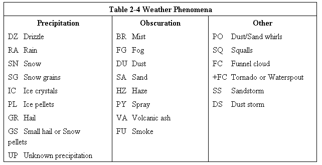
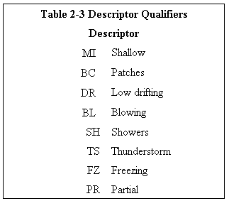
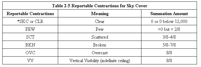
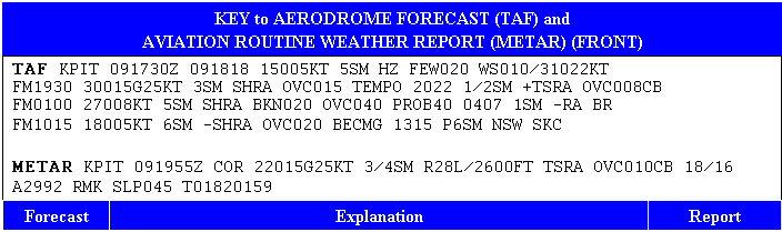
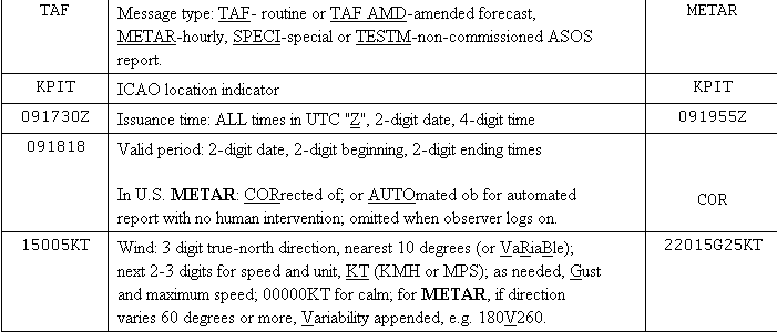
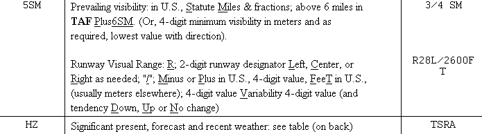
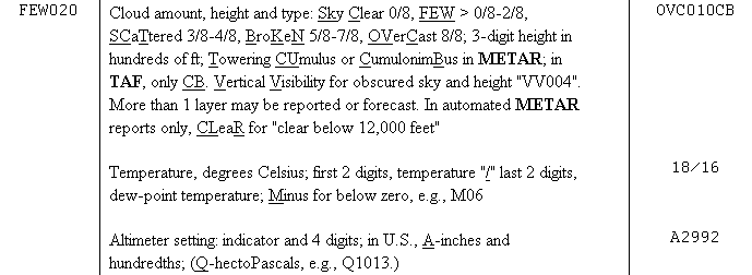
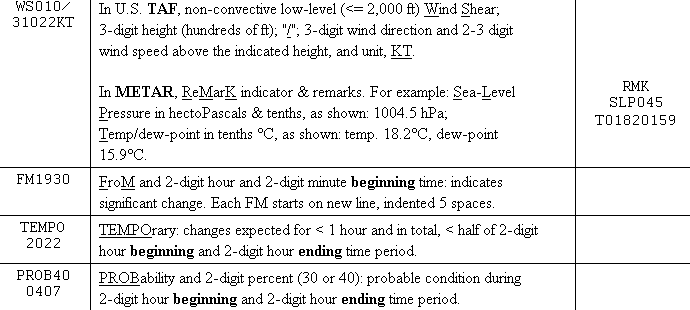
FORECAST CHANGE INDICATORS If a significant change in any of the elements is expected during the valid period, a new time period with the changes is included. The following change indicators are used when either a rapid, gradual, or temporary change is expected in some or all of the forecasted meteorological conditions. From (FM) Group The FM group is used when a rapid and significant change, usually occurring in less than 1 hour, in prevailing conditions is expected. Appended to the FM indicator is the four-digit hour and minute the change is expected to begin. The forecast is valid until the next change group or until the end of the current forecast. The FM group will mark the beginning of a new line in a TAF report. Each FM group shall contain a forecast of wind, visibility, weather (if significant), sky condition, and wind shear (if warranted). FM groups will not include the contraction NSW. Examples: FM1500 16015G25KT P6SM SCT040 BKN250 FM0200 32010KT 3SM TSRA FEW010 BKN030CB Becoming (BECMG) Group The BECMG group is used when a gradual change in conditions is expected over a period not to exceed 2 hours. The time period when the change is expected to occur is a four-digit group containing the beginning and ending hours of the change that follows the BECMG indicator. The gradual change will occur at an unspecified time within the time period. Only the changing forecasted meteorological conditions are included in BECMG groups. Omitted conditions are carried over from the previous time group. Example: FM2000 18020KT P6SM BKN030 BECMG 0103 OVC015 This BECMG group describes a gradual change in sky condition from BKN030 to OVC015. The change in sky conditions occurs between 01Z and 03Z. Refer back to the FM2000 group for the wind and visibility conditions. The forecast after 03Z will be: 18020KT P6SM OVC015. Example: FM0400 14008KT P6SM SCT040 OVC080 TEMPO 0408 3SM TSRA OVC030CB BECMG 0810 32007KT= This BECMG group describes a gradual change in wind direction only beginning between 08Z and 10Z. Refer back to the previous forecast group, in this case the FM0400 group, for the prevailing visibility, weather, and sky conditions. The forecast after 10Z will be: 32007KT P6SM SCT040 OVC080. Temporary (TEMPO) Group The TEMPO group is used for temporary fluctuations of wind, visibility, weather, or sky condition that are expected to last for generally less than an hour at a time (occasional), and expected to occur during less than half the time period. The TEMPO indicator is followed by a four-digit group giving the beginning and ending hours of the time period during which the temporary conditions are expected. Only the changing forecasted meteorological conditions are included in TEMPO groups. The omitted conditions are carried over from the previous time group. Example: FM1000 27005KT P6SM SKC TEMPO 1216 3SM BR This temporary group describes visibility and weather between 12Z and 16Z. The winds and sky condition have been omitted. Go back to the previous forecast group, FM1000, to obtain the wind and sky condition forecast. The forecast between 12Z and 16Z is: 27005KT 3SM BR SKC. Example: FM0400 14008KT P6SM SCT040 OVC080 TEMPO 0408 3SM TSRA OVC030CB BECMG 0810 32007KT= This temporary group describes visibility, weather, and sky condition between 04Z and 08Z. The winds have been omitted. Go back to the previous forecast group, FM0400, to obtain the wind forecast. The forecast between 04Z and 08Z is: 14008KT 3SM TSRA OVC030CB. PROBABILITY (PROB30 or PROB40) FORECAST TAF KPIR 111140Z 111212 13012KT P6SM BKN100 WS020/35035KT TEMPO 1214 5SM BR FM1500 16015G25KT P6SM SCT040 BKN250 FM0000 14012KT P6SM BKN080 OVC150 PROB40 0004 3SM TSRA BKN030CB FM0400 14008KT P6SM SCT040 OVC080 TEMPO 0408 3SM TSRA OVC030CB BECMG 0810 32007KT= The probability forecast describes the probability or chance of thunderstorms or other precipitation events occurring, along with associated weather conditions (wind, visibility, and sky conditions). The probability forecast will not be used in the first 6 hours of the TAF. The PROB30 or PROB40 group is used when the occurrence of thunderstorms or precipitation is in the 30% to less than 40% or 40% to less than 50% range, respectively. If the thunderstorms or precipitation chance is greater than 50%, it is considered a prevailing weather condition and is included in the significant weather section or the TEMPO change indicator group. PROB30 or PROB40 is followed by a four-digit time group giving the beginning and ending hours of the time period during which the thunderstorms or precipitation is expected. Example: FM0600 0915KT P6SM BKN020 PROB30 1014 1SM RA BKN015 This example depicts a 30% to less than 40% chance of 1statute mile, moderate rain, and a broken cloud layer (ceiling) at 1,500 feet between the hours of 10-14Z. Example: FM0000 14012KT P6SM BKN080 OVC150 PROB40 0004 3SM TSRA BKN030CB In this example, there is a 40% to <50% chance of visibility 3 statute miles, thunderstorms with moderate rain showers, and a broken cloud layer (ceiling) at 3,000 feet with cumulonimbus between the hours of 00-04Z. |
|
| Index |
7-1-5. INFLIGHT WEATHER ADVISORIES a. The NWS issues inflight weather advisories designated as Severe Weather Forecast Alerts (AWW's), Convective SIGMET's (WST's), SIGMET's (WS's), Center Weather Advisories (CWA's), and AIRMET's (WA's). Inflight advisories serve to notify en route pilots of the possibility of encountering hazardous flying conditions which may not have been forecast at the time of the preflight briefing. |
|
| Index |
When requesting a preflight briefing,
identify yourself as a pilot and provide the following: 1. Type of flight planned, e.g., VFR or IFR. 2. Aircraft's number or pilot's name. 3. Aircraft type. 4. Departure Airport. 5. Route of flight 6. Destination. 7. Flight altitude(s). 8. ETD and ETE. |
|
| Index |
AIRMET's (WA's) may be of significance to any
pilot or aircraft operator and are issued for all domestic airspace.
They are of particular concern to operators and pilots of aircraft
sensitive to the phenomena described and to pilots without instrument
ratings and are issued by the AWC for the following weather phenomena
which are potentially hazardous to aircraft: 1. Moderate icing. 2. Moderate turbulence. 3. Sustained winds of 30 knots or more at the surface. 4. Widespread area of ceilings less than 1,000 feet and/or visibility less than three miles. 5. Extensive mountain obscurement. i. AIRMET's are issued on a scheduled basis every six hours, with unscheduled amendments issued as required. AIRMET's have fixed alphanumeric designator with ZULU for icing and freezing level data, TANGO for turbulence, strong surface winds, and windshear, and SIERRA for instrument flight rules and mountain obscuration. |
|
| Index |
SIGMET's (WS's) within the conterminous U.S. are
issued by the Aviation Weather Center (AWC) when the following phenomena
occur or are expected to occur: 1. Severe or extreme turbulence or clear air turbulence (CAT) not associated with thunderstorms. 2. Severe icing not associated with thunderstorms. 3. Duststorms, sandstorms, or volcanic ash lowering surface or inflight visibilities to below three miles. 4. Volcanic eruption. |
|
| Index |
Convective SIGMET's (WST's) in the
Conterminous U.S.: WST's concern only thunderstorms and related
phenomena (tornadoes, heavy precipitation, hail, and high surface winds)
over the conterminous U.S. and imply the associated occurrence of
turbulence, icing, and convective low level wind shear. Individual WST's
for each day are numbered sequentially (00-1-99), beginning at 00Z. The
affected geographic area is contained in the number; i.e., the first WST
issued each day in the eastern U.S. is Convective SIGMET 1E, the second
is Convective SIGMET 2E, and so forth. WST's are issued on a scheduled
basis, hourly at 55 minutes past the hour (H+55), and are valid for two
hours or until superseded by the next hourly update. WST's are issued
for any of the the following phenomena: 1. Severe thunderstorm due to: (a) surface winds greater than or equal to 50 knots. (b) hail at the surface greater than or equal to 3/4 inches in diameter. (c) tornadoes. 2. Embedded thunderstorms. 3. A line of thunderstorms. 4. Thunderstorms greater than or equal to VIP level 4 affecting 40% or more of an area at least 3,000 square miles. |
|
| Index |
TWEB Equipment is provided at three AFSS/FSS locations in the lower 48 states and all of Alaska, by which meteorological and aeronautical data are recorded on tapes and broadcast continuously over selected low-frequency (190-535 kHz) navigational aids NDB's and/or VOR's. Broadcasts are made from a series of individual tape recordings, and changes, as they occur, are transcribed onto the tapes. The information provided varies depending on the type equipment available. Generally, the broadcast contains route-oriented data with specially prepared NWS forecasts, Inflight Advisories, and winds aloft plus preselected current information, such as weather reports (METAR/SPECI), NOTAM's, and special notices. |
|