|
|
|||
|
Index
|
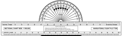
Sectional Charts Sectional charts are the most common charts used by pilots today. The charts have a scale of 1:500,000 (1 inch = 6.86 nautical miles or 8 statute miles) which allows for more detailed information to be included on the chart. The charts provide an abundance of information, including airport data, navigational aids, airspace, and topography etc. By referring to the chart legend, a pilot can interpret most of the information on the chart. A pilot should also check the chart for other legend information which includes air traffic control frequencies and information on airspace. These charts are revised semiannually except for some areas outside the contiguous United States where they are revised annually. Visual Flight Rule (VFR) Terminal Area Charts Visual flight rule terminal area charts are helpful when flying in or near Class B airspace. They have a scale of 1:250,000 (1 inch =3.43 nautical miles or 4 statute miles). These charts provide a more detailed display of topographical information and are revised semiannually, except for several Alaskan and Caribbean charts. World Aeronautical Charts |
||
|
|
|
||
| Index |
 |
||
|
|
|
||
 |
|||
|
|
|
||
| Index |
 |
||
|
|
|
||
| Index |
 |
||
|
|
|||
| Index |
 |
||
|
|
|||
 |
|||
|
|
|||
| Index |
 |
||
|
|
|||
| Index |
 |
||
|
|
|||
| Index |
 |
||
|
|
|||
| Index |
 |
||
|
|
|||
|
Index
|
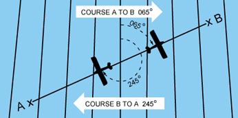
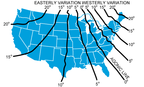
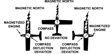
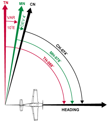
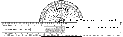
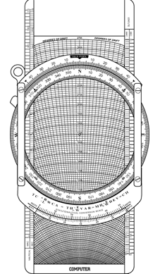
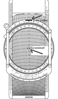
• TRUE COURSE—Direction of the line
connecting two desired points, drawn on the chart and measured clockwise
in degrees from true north on the mid-meridian. • WIND CORRECTION ANGLE—Determined from the wind triangle. (Added to TC if the wind is from the right; subtract if wind is from the left.) • TRUE HEADING—The direction measured in degrees clockwise from true north, in which the nose of the plane should point to make good the desired course. • VARIATION—Obtained from the isogonic line on the chart. (Added to TH if west; subtract if east.) • MAGNETIC HEADING—An intermediate step in the conversion. (Obtained by applying variation to true heading.) • DEVIATION—Obtained from the deviation card on the airplane. (Added to MH or subtracted from, as indicated.) • COMPASS HEADING—The reading on the compass (found by applying deviation to MH) which will be followed to make good the desired course. • TOTAL DISTANCE—Obtained by measuring the length of the TC line on the chart (using the scale at the bottom of the chart). • GROUNDSPEED—Obtained by measuring the length of the TC line on the wind triangle (using the scale employed for drawing the diagram). • TIME FOR FLIGHT— Total distance divided by groundspeed. • FUEL RATE—Predetermined gallons per hour used at cruising speed. |
||
|
|
|||
|
Index
|
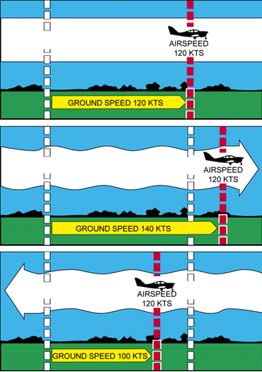
Converting Minutes to Equivalent
Hours It frequently is necessary to convert minutes into equivalent hours when solving speed, time, and distance problems. To convert minutes to hours, divide by 60 (60 minutes = 1 hour). Thus, 30 minutes 30/60 = 0.5 hour. To convert hours to minutes, multiply by 60. Thus, 0.75 hour equals 0.75 x 60 = 45 minutes. Time T = D/GS To find the time (T) in flight, divide the distance (D) by the groundspeed (GS). The time to fly 210 nautical miles at a groundspeed of 140 knots is 210 divided by 140, or 1.5 hours. (The 0.5 hour multiplied by 60 minutes equal 30 minutes.) Answer: 1:30. Distance D = GS X T To find the distance flown in a given time, multiply groundspeed by time. The distance flown in 1 hour 45 minutes at a groundspeed of 120 knots is 120 x 1.75, or 210 nautical miles. Groundspeed GS = D/T To find the groundspeed, divide the distance flown by the time required. If an airplane flies 270 NM in 3 hours, the groundspeed is 270 divided by 3 = 90 knots. Converting Knots to Miles Per Hour Another conversion is that of changing knots to miles per hour. The aviation industry is using knots more frequently than miles per hour, but it might be well to discuss the conversion for those who do use miles per hour when working with speed problems. The National Weather Service reports both surface winds and winds aloft in knots. However, airspeed indicators in some airplanes are calibrated in miles per hour (although many are now calibrated in both miles per hour and knots). Pilots, therefore, should learn to convert windspeeds in knots to miles per hour. A knot is 1 nautical mile per hour. Because there are 6,076.1 feet in a nautical mile and 5,280 feet in a statute mile, the conversion factor is 1.15. To convert knots to miles per hour, multiply knots by 1.15. For example: a windspeed of 20 knots is equivalent to 23 MPH. Most flight computers or electronic calculators have a means of making this conversion. Another quick method of conversion is to use the scales of nautical miles and statute miles at the bottom of aeronautical charts. Fuel Consumption Airplane fuel consumption rate is computed in gallons per hour. Consequently, to determine the fuel required for a given flight, the time required for the flight must be known. Time in flight multiplied by rate of consumption gives the quantity of fuel required. For example, a flight of 400 NM at a groundspeed of 100 knots requires 4 hours. If the plane consumes 5 gallons an hour, the total consumption will be 4 x 5, or 20 gallons. The rate of fuel consumption depends on many factors: condition of the engine, propeller pitch, propeller RPM, richness of the mixture, and particularly the percentage of horsepower used for flight at cruising speed. The pilot should know the approximate consumption rate from cruise performance charts, or from experience. In addition to the amount of fuel required for the flight, there should be sufficient fuel for reserve. |
||
|
|
|||
| Index |
  |
||
|
|
|||
| Index |
Q: How far will an aircraft travel in 2-1/2 minutes with a groundspeed
of 98 knots? A) 2.45 NM. B) 3.35 NM. C) 4.08 NM. A: With a calculator, convert the values to like terms. Convert 98 KTS (Nautical Miles per Hour) to Nautical Miles per Minute, by dividing by 60 = 1.6333 nm / Minute. At that speed, multiply by 2.5 minutes to get the answer 4.08 NM. (98 / 60 x 2.5)
|
||
|
|
|||
| Index |
  |
||
|
|
|||
| Index |
  |
||
